Monthly Archives: December 2015

Finally some rain for Southern California

December 30, 2015


Finally some rain may be in the forecast for Southern California. After a record warm Christmas in New York, historic flooding in Missouri, deadly winter tornadoes, and a healthy snowfall in El Paso, it may finally rain in Los Angeles. The warm Christmas in NYC, the flooding in Missouri,  and the Christmas week snow in El Paso all happened in the last  few days AND are all repeats of events in December 1982.

Parts of The Cascades are buried, 9 feet around Crater Lake. The Lake Tahoe area has seen feet of snow in recent weeks as has portions of the Northern and Central Sierra. The last piece of the puzzle is Southern California rain.

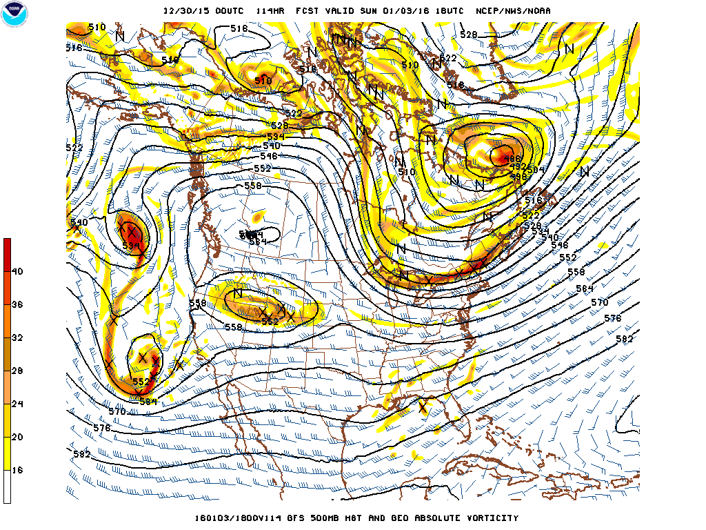
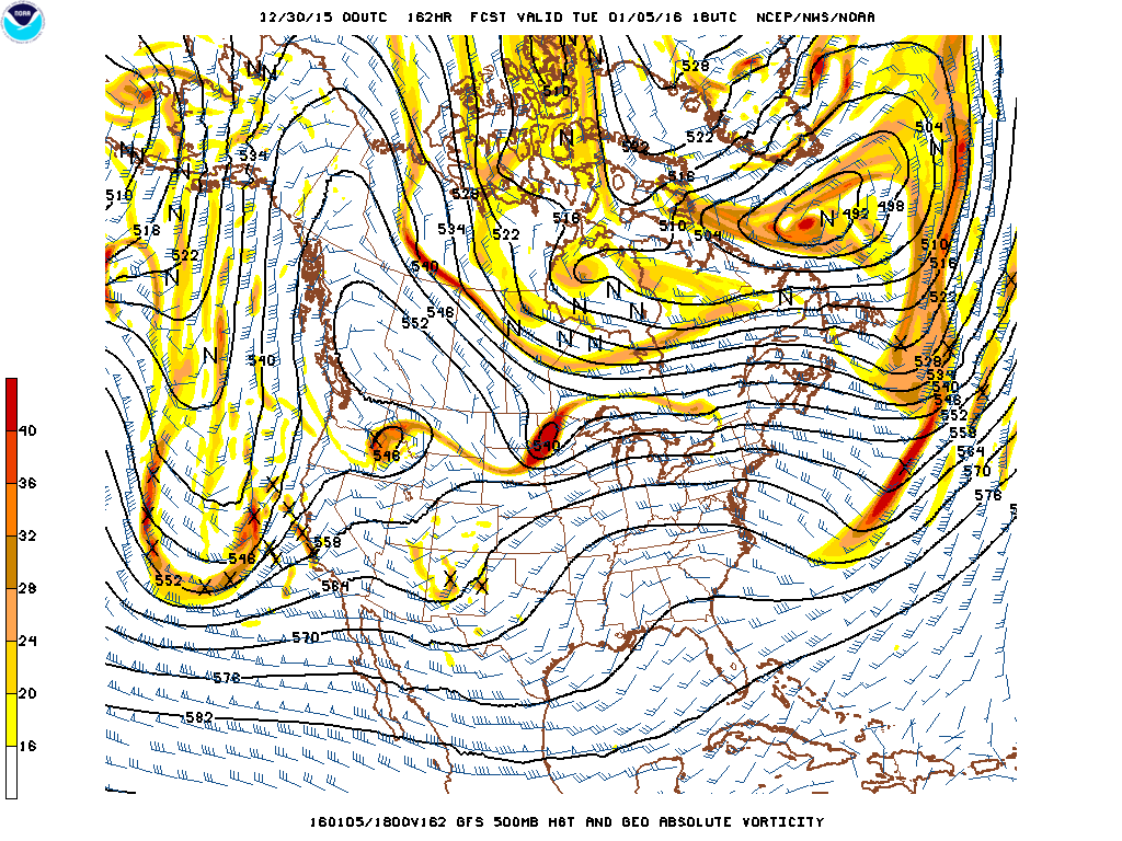
Finally some rain may be in the forecast for Southern California. Two distinct short waves approach Southern California Sunday and Tuesday of the upcoming week.

Forecast 500mb flow for midday Sunday January 03, 2016.

December 30, 2015Bloggfs_namer_114_1000_500_thick

Forecast 500mb flow for midday Tuesday January 05, 2016.

December 30, 2015Bloggfs_namer_162_1000_500_thick

Learn more in my latest e-book El Niño:  The WILD side of the weather cycle…
What we know, what we don’t, and WHY you should care!

I show how this years Pacific water temperatures compare to the 1982 and 1997 events and highlight the kind of weather episodes that these stronger El Niño’s tend to bring.

If you like the blog you will love the book.

Cover2 redo

Available at Amazon

Wild Bill.

Contrast highlights Holiday weather across the nation

December 28, 2015

Not just a warm Holiday for some in the East, but a record warm Christmas Holiday. This is just a sample of the hundreds of record high temperatures that have been set across the eastern half of the nation in recent weeks. Some locations like New York’s Central Park set a high temperature record on both Christmas Eve and Christmas Day.  Albany New York was 15 degrees warmer than any other Christmas Eve on record and Burlington Vermont was 17 degrees warmer than the previous record. In places like  Vermont, where a White Christmas is expected, temperatures nearly 40 degrees above normal are not only noticeable but crippling to the ski and winter industries. Ice and snow just don’t hold up to temps in the 60s and lower 70s.

December 24, 2015 Record Highs Christmas Eve

Central Park NYC          72R  1131 AM  63    1996
Albany ALB                      72R    220 PM  57    1941
Boston BOS                     69R    359 PM  61    1996
Hartford BDL                  69R    259 PM  59    1996
Providence PVD            69R    404 PM  64    2014
Burlington BTV              68R    154 PM  51    1957

December 25, 2015 Record Highs Christmas Day

Central Park NYC                   66R  1231 AM  64    1982
John F. Kennedy JFK           64R    256 PM  58    1982
Providence PVD                     64R    228 PM  63    2014
Worchester ORH                    60Rt  153 PM  60    1964

Philadelphia PHL                  68Rt   225 PM  68    1964
Washington Dulles IAD          70    215 PM  71    1982

Atlanta ATL                            75R      452 PM  72    1987
Athens AHN                           77Rt     254 PM  77    1982

The unusually warm weather not only set records, but also set the stage for several rounds of deadly severe weather.  Several fatalities occurred across Mississippi and Tennessee from a long track EF-3 tornado on Wednesday the 23rd. An EF-2 tornado struck a Birmingham suburb on Christmas Day. Damage was significant but no fatalities occurred.  A new storm system on the 26th was still able to take advantage of the unusually warm weather.  An EF-4 steamrolled the Dallas suburb of Garland killing eight in the early evening hours.

Brief review of Holiday severe weather:

December 23, 2015, …10 fatalities were reported in Mississippi, six were killed in Tennessee. One tornado producing thunderstorm tracked 145 miles from the Mississippi River across the state and into Tennessee killing 7. Other fatalities occurred due to tornadoes, straight-lines winds and flooding.

December 25, 2015, … EF-2 tornado swirled across portions of McCalla and Bessemer Alabama, immediate suburbs of Birmingham, collapsing houses but not killing anyone.

December 26, 2015, …11 died in Texas after several tornadoes were reported in the Dallas area.  In Garland, a suburb of Dallas, eight people died Saturday from an EF-4 tornado, three others died in Collin County just to the north.

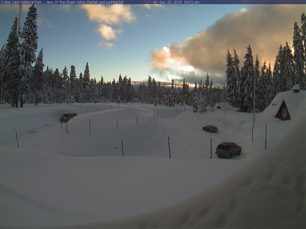
In contrast,  the Cascades of Oregon looked quite wintry on the Holiday. Below are images from last Christmas, this Christmas and June 1st.

The Steel Visitors Center Crater at Lake National Park on Christmas Day 2014.steelvisitorcenter 14-12-25-1
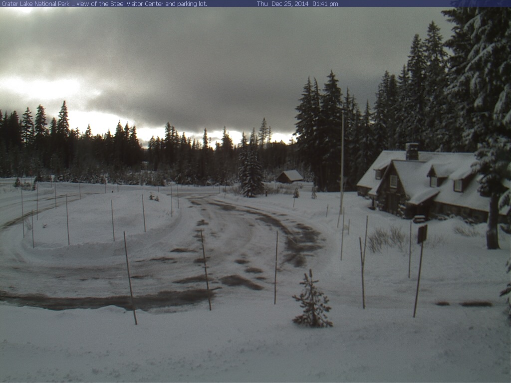
The Steel Visitors Center Crater at Lake National Park on Christmas Day 2015.

At 7050 feet the snow depth listed for Christmas Day 2015 was 111 inches, or a little over 9 feet. That is a full size van parked back left and the snow banks are well above.steelvisitorcenter15-12-25-03
The Steel Visitors Center Crater at Lake National Park on June 01, 2014.                                 Even in a drought year the snow cover lingers until June.steelvisitorcenter 14-06-01-1
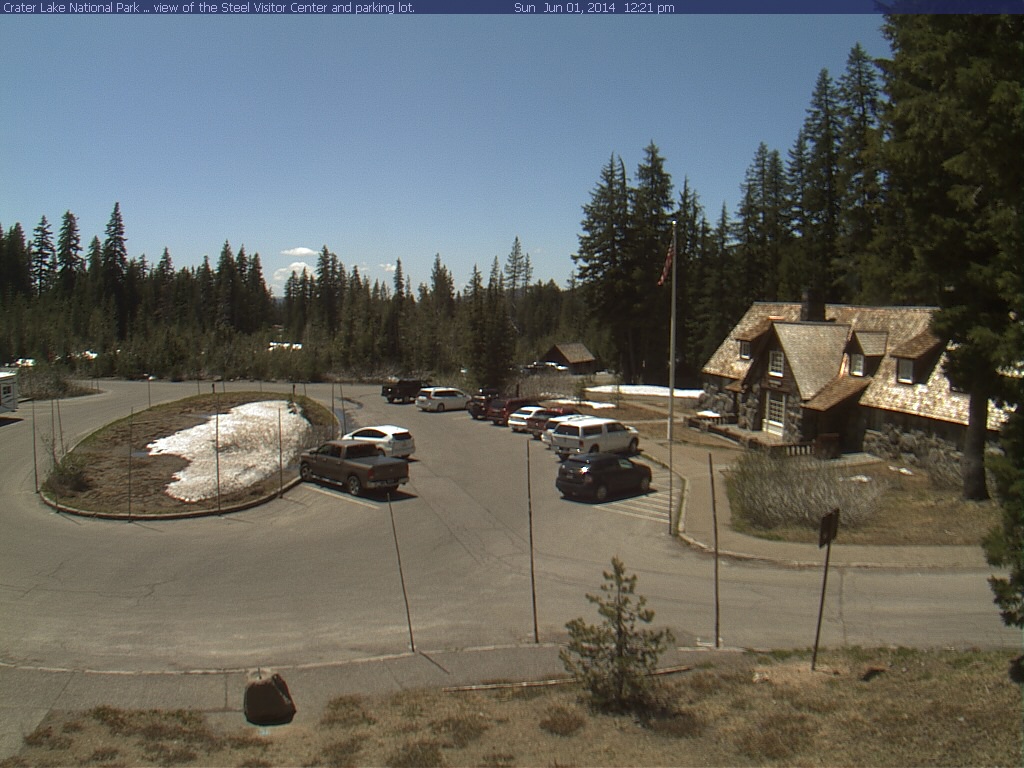
Just to show anyway you look at it,  Crater Lake was buried for this Holiday.  A series of West Coast storms have left there mark on the mountains of the West.

Learn more in my latest e-book El Niño:  The WILD side of the weather cycle…
What we know, what we don’t, and WHY you should care!

I show how this years Pacific water temperatures compare to the 1982 and 1997 events and highlight the kind of weather episodes that these stronger El Niño’s tend to bring.

Central Park NYC                   66R  1231 AM  64    1982

If you like the blog you will love the book.
Cover2 redo

Available at Amazon

Wild Bill.
Warm in the days before Christmas for a third year.

December 18, 2015

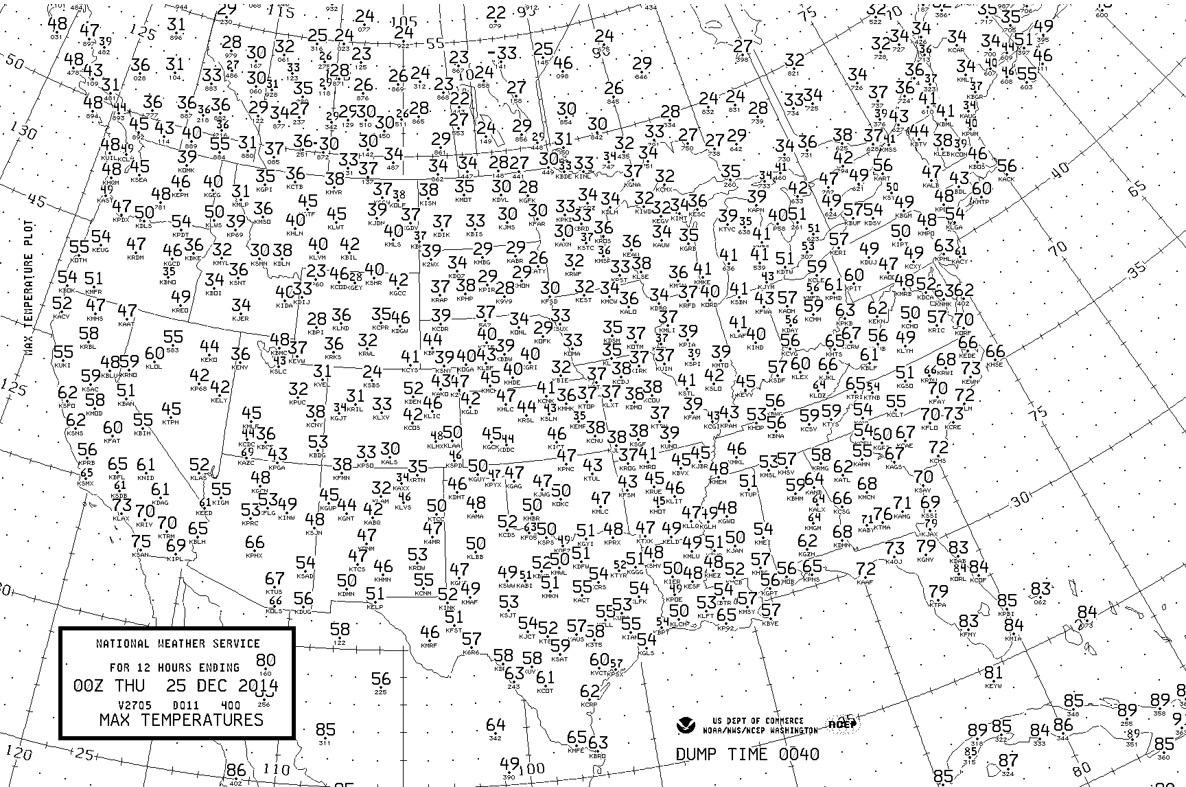
It looks like warm weather across the parts of the East in the days before Christmas for the third year in a row.

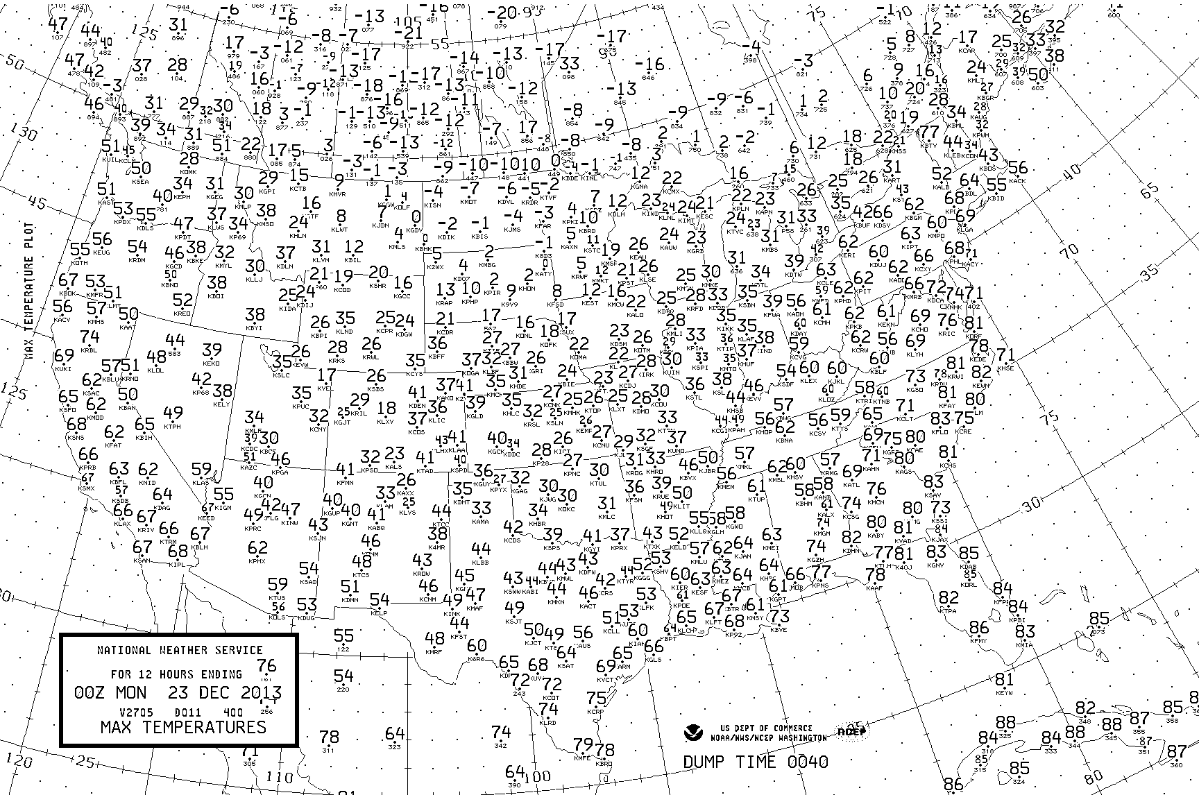
Maximum temperatures December 22, 2013, … 60’s to low 70s across Mid-Atlantic StatesDecember 18, 2015blogmaxtempwarmeastdec22,2013

Maximum temperatures December 24, 2014, … not as warm as 2013, but well above freezing. 60 at Pittsburgh however,  is only 2 cooler than its 2013 reading.December 18, 2015blogmaxtempwarmeastdec24,2014

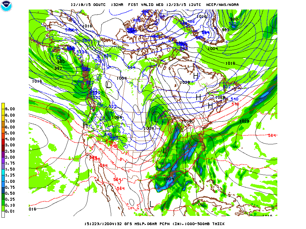
Forecast for this December 23, 2015 also looks quite warm. The forecast for Pittsburgh is for a daytime high near 60. This will make three years in a row Pittsburgh will have been near 60 degrees in the days before Christmas. Normal high for December 23 for Pittsburgh is 37, making a high of 60,  23 degrees above normal.

Well below normal temperatures were experienced in Pittsburgh on December 22, 1989 when the high was only 7 above, and December 25, 1983 the high for Pittsburgh was zero.

So do not move to Pittsburgh and expect 60 degree pre-Christmas weather every year, but right now it certainly is in the forecast again this year, for the third year in a row.

December 18, 2015Bloggfs_namer_132_1000_500_Dec23, 2015

Red lines in the image above relate to above freezing temperatures. Note no blue line anywhere near Pennsylvania on this Dec. 23.  How are today’s kids suppose to relate to “A Charles Brown Christmas” when there is no ice on the ponds and no snow on the ground for the third year in a row.

Learn more in my latest e-book El Niño:  The WILD side of the weather cycle…
What we know, what we don’t, and WHY you should care!

I show how this years Pacific water temperatures compare to the 1982 and 1997 events and highlight the kind of weather episodes that these stronger El Niño’s tend to bring.

If you like the blog you will love the book.

Cover2 redo

Available at Amazon

Wild Bill.
Feeling the effects of warm Pacific water

December 14, 2015

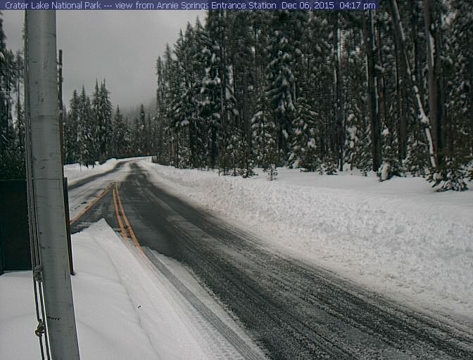
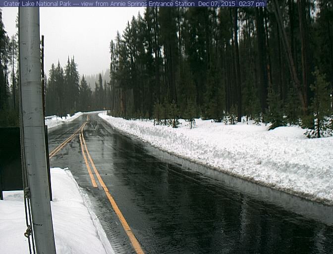
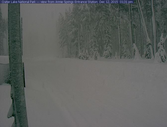
Various conditions at the entrance to Crater Lake National Park at times during the past week.

ANNIE SPRINGS, OR.  ANSO3  (SNOTEL)
Elev: 6010 ft; Latitude: 42.87007; Longitude:  122.16518                                                                                                snow                     total

(PST)                                                        (f)                                                                    Depth(inches) Precip(inches)
06 Dec 11:00 pm PST 35 23.00 11.50

annesprings15-12-06-01

Above recent heavy snow with temperatures slight above freezing, below rain and 42.

07 Dec 2:00 pm PST 42 21.00 12.20

annesprings15-12-07-01

Finally colder, slightly below freezing air,  several days later and the snow depth doubles from 21 to 42 inches. So what you cannot see is nearly four feet of snow on the ground at the lowest elevation in Crater Lake National Park.

12 Dec 2:00 pm PST 30 42.00 17.20

annesprings15-12-12-01

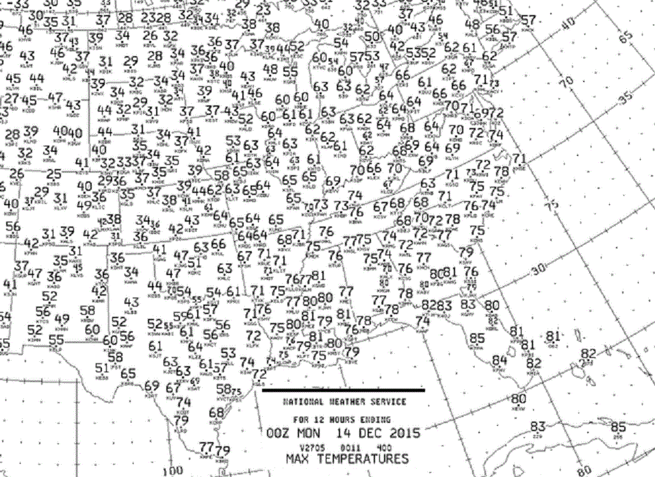
All the above quite the contrast to a record warm weekend. Sunday was the second weekend day of records highs in mid December over parts of the eastern half  of the nation.

December 13, 2015max temps - Copy

We were very lucky there was not more serious severe weather this past weekend.

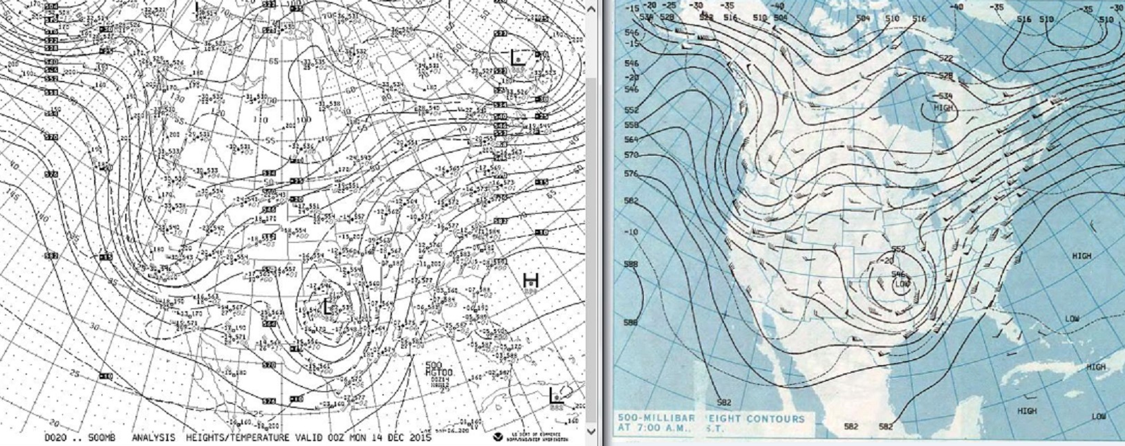
Record warm mid December temperatures and a favorable 500mb flow for severe weather were both present this weekend in the middle of the country. Map on the left from this Sunday evening 00z the 14th, in the blue on the right, Sunday morning November 22, 1992, the middle of a 3 day tornado outbreak.

December 14, 2015500mb00zcomparenov92 - Copy

Learn more in my latest e-book El Niño:  The WILD side of the weather cycle…
What we know, what we don’t, and WHY you should care!

I show how this years Pacific water temperatures compare to the 1982 and 1997 events and highlight the kind of weather episodes that these stronger El Niño’s tend to bring.

If you like the blog you will love the book.

Cover2

Available at Amazon

Wild Bill.
New storm spreads threats south into California

December 10, 2015

New storm spreads threats south into California.

Below one of the last visible pictures of the day showing the next system approaching.December 09, 2015satellitewest2345z - Copy

Below are some rather strong statements from the NWS late Wednesday concerning various Marine threats as far south as Ventura County in Southern California. Sounds more like an El Niño season for Southern California, but this is not the big wet pattern that is highly anticipated for LA and San Diego, just a passing wave. The hope of course, in time, more waves and a jet stream a little farther south and an active winter is in business.

709 PM PST WED DEC 9 2015

LARGE POWERFUL SWELL EXPECTED THURSDAY THROUGH SATURDAY…

A LARGE WEST TO NORTHWESTERLY SWELL IS EXPECTED TO PRODUCE
BREAKING WAVES AT THE MORRO BAY AND VENTURA HARBOR ENTRANCES
THURSDAY THROUGH SUNDAY. THESE CONDITIONS HAVE A HISTORY OF
CAPSIZING VESSELS OF VARIOUS SIZES RESULTING IN SERIOUS INJURY OR
DEATH…EVEN TO THE MOST EXPERIENCED MARINERS. MARINERS ARE URGED
TO STAY CLEAR OF THESE HARBOR ENTRANCES.

* IMPACTS…THE CENTRAL COAST COULD SEE SURF FROM 16 TO 22 FEET.
BEACHES SOUTH OF POINT CONCEPTION COULD SEE SURF FROM 8 TO 12
FEET. THERE IS A CHANCE THAT THESE WAVES WILL BE STRONG ENOUGH
  TO DAMAGE COASTAL STRUCTURES…SUCH AS PIERS. THERE IS THE
POTENTIAL FOR MINOR FLOODING IN AND AROUND BEACH AREAS.

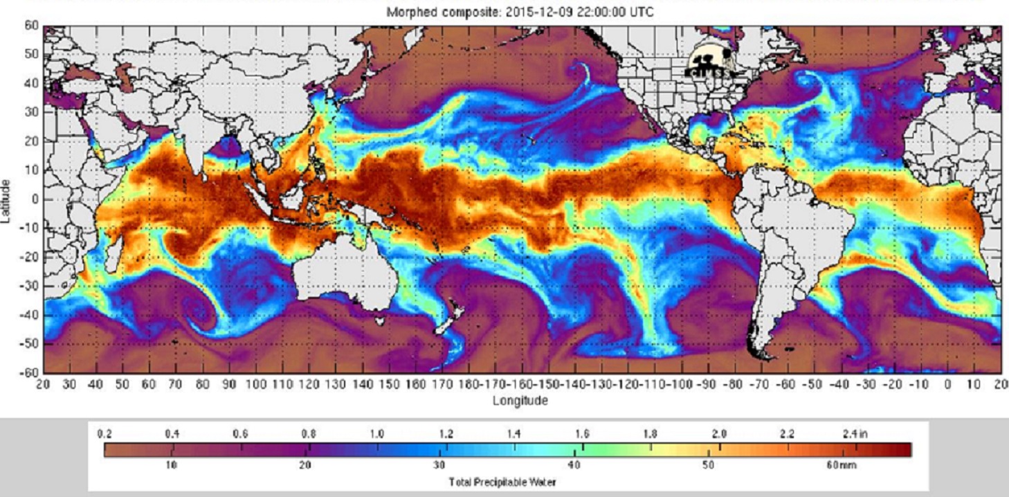
Below, image showing trail of water vapor across Pacific into the West Coast. Another trail of moisture stretches from the Caribbean across the Atlantic to the British Isles.  Both areas have seen flooding rains in recent days.

December 09, 2015vapormorphed2245z -Blog - Copy

December 09, 2015vapormorphed2245z - Copy

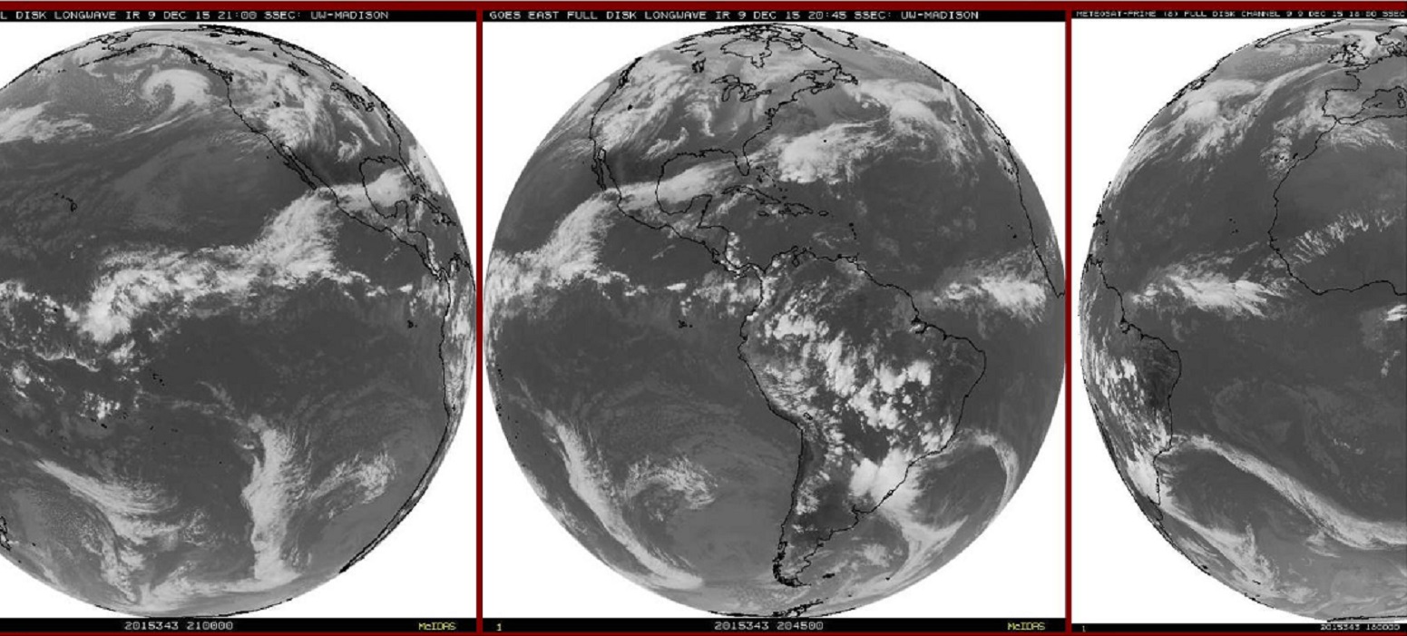
Standard full disk IR showing Pacific system racing toward  West Coast. But also shows our El Niño region feeding clouds across Mexico and into the Atlantic. Here is a rare look at simultaneous full disk images  showing a trail of clouds from the tropical Pacific all the way to Europe.  Between our Pacific Northwest and the British Isles I would not think  England would see the more serious flood because of excess El Niño moisture. But these current images tell a clear story.  West Coast flooding could be a worse if there were a direct link to the El Niño  region of the Pacific.

December 09, 2015satepage0935z - BlogCopy - Copy

December 09, 2015satellitepage2115z - Copy

All this active West Coast weather is not only finally going to bring some increment weather to Southern California. But will push east into the United States and bring many a stormy weekend. More on all that in the next day or two. Think ahead, stay safe.

Learn more in my latest e-book El Niño:  The WILD side of the weather cycle…
What we know, what we don’t, and WHY you should care!

I show how this years Pacific water temperatures compare to the 1982 and 1997 events and highlight the kind of weather episodes that these stronger El Niño’s tend to bring.

If you like the blog you will love the book.

Cover2

Available at Amazon

Wild Bill.
Milestone, ONI reaches +2.0

December 08, 2015

An ONI of +2.0 means El Niño is here, it is happening, and it is happening well into spring.

The book, and the blog, all in anticipation of the possibility of an ONI of +2.0. Everything discussed in the book and covered by Wild Bill’s Blog are a possibility for the winter and spring. Floods, flash floods, tornadoes, wind and winter storms that is, not necessarily 200mph hurricanes.  But record events, like Northern England this past weekend. The recent rain broke records set in the last El Niño in 2009.

We have followed the weekly anomalies and compared them to 1997 since late September, so this high ONI value is no big surprise.  But it does validate the investment in the subject. This is a much longer term average with fancy curve smoothing and high frequency filters. It makes the research scientist happy. Now the event is not just a curiosity, or some weatherman’s whim. It is statistically and mathematically significant. In the world of science math is the foundation, … and Math says this El Niño is significant.

So batten down the hatches and call your neighbor when the weather is on. Use the quiet weather periods to prepare for the bad. Keep watch even when the forecast seems quiet and certain. Some weather patterns are predicable for several days, others change overnight. Overnight surprises could be inches of rain, or inches of snow, maybe from above freezing to below zero or destructive tornadoes.

While I would like to say “nothing like that in the current forecast”,   but the 10 day outlook actually  looks rather eventful. Flooding in parts of the Pacific Northwest next few days, nasty system maybe severe central portions of the country over the weekend, followed by colder temperatures, …. and it all heads east, then repeats much of next week.

And maybe Southern California will see something in the next week or so, …but still waiting for the big Los Angeles storm  that says this El Niño is for real.

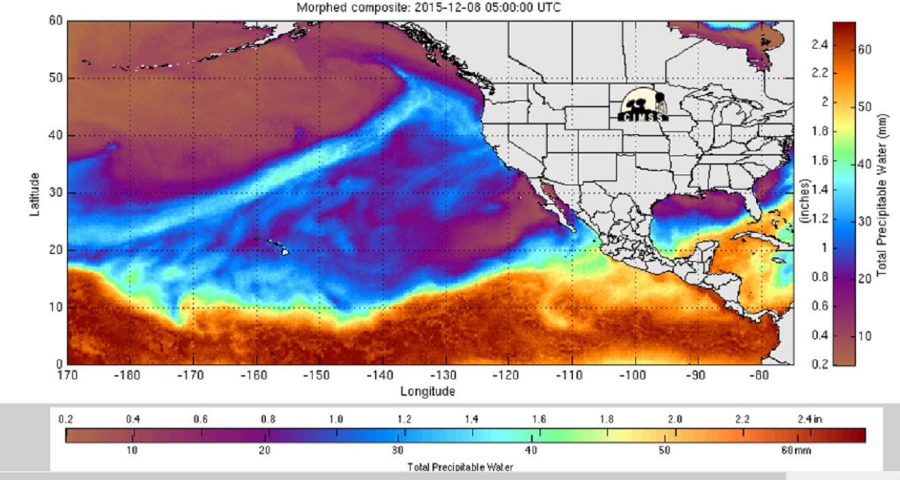
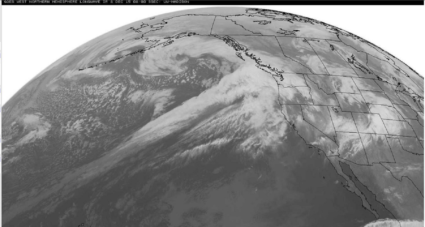
River of moisture headed into the Northwest on this Tuesday

water vapor followed by regular IR satellite.

December 08, 2015norhemvapormorph0500z - Copy

December 08, 2015westnorthhemiIR0800z - Copy

Learn more in my latest e-book El Niño:  The WILD side of the weather cycle…
What we know, what we don’t, and WHY you should care!

I show how this years Pacific water temperatures compare to the 1982 and 1997 events and highlight the kind of weather episodes that these stronger El Niño’s tend to bring.

If you like the blog you will love the book.

Cover2

Available at Amazon

Wild Bill.
Second storm in the series about to roar ashore

December 05, 2015

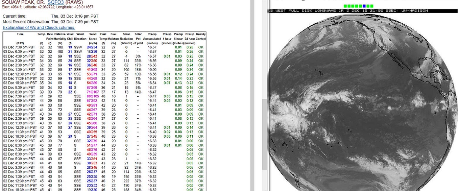
The first wave of low pressure that rolled onshore Thursday did produce some high wind. Frame below shows 36 hours of observations from a high wind location along with full disk satellite image of system pushing on shore.December 03, 2015 Bloglatestoregonwind2345zjpg - Copy

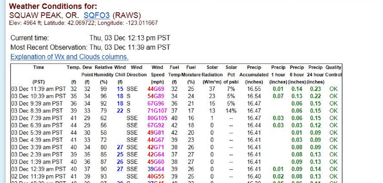
A closer view of highest winds observed at this location shows gust over 100mph at the height of the storm.December 03, 2015 Bloglatestoregonwind1800zjpg - Copy

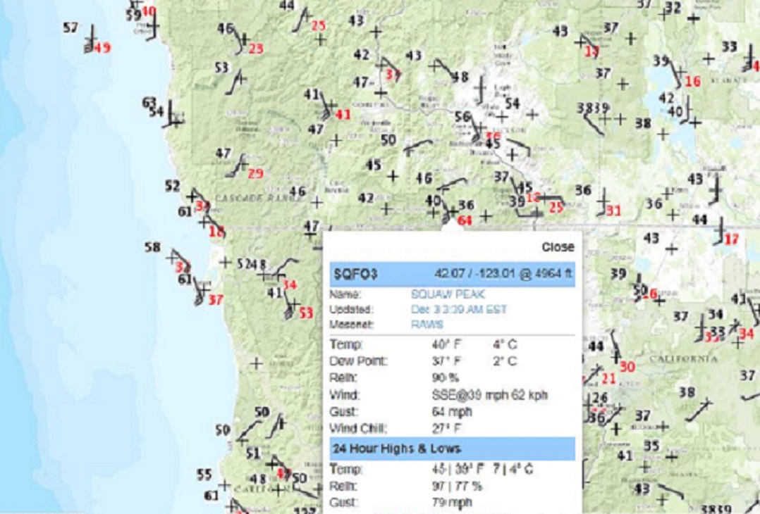
Below an attempt to show location of Squaw Peak along the California Oregon border and further illustrate it is a real observation point accessible through NWS websites.  The observation below does have a time of 3:39EST. To match the wind speed and gusts to the observations above, look at the 12:39PST observation.December 03, 2015 Bloglatestoregonwind0803zjpg - Copy

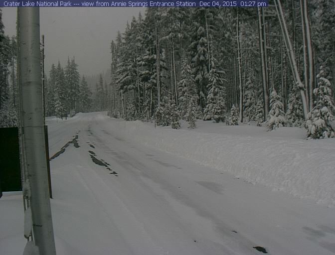
And yes it snowed, at least for some, this is from Crater Lake National Park, elevation over 6000 feet.  Located just off the northeast corner of the map above.annesprings15-12-04-01

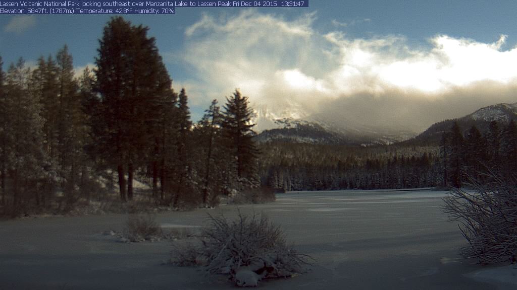
Mount Lassen and Manzanita Lake experience of brief clearing late on Friday after the storm brought snowfall to the area on Thursday and Thursday night.Lassen Peak15-12-04-03

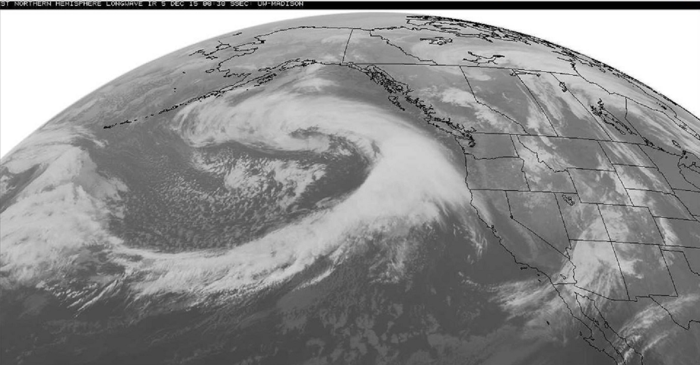
Now the Second storm in the series is about to roar ashore

December 05, 2015westnorthhemiIR0000z - Copy

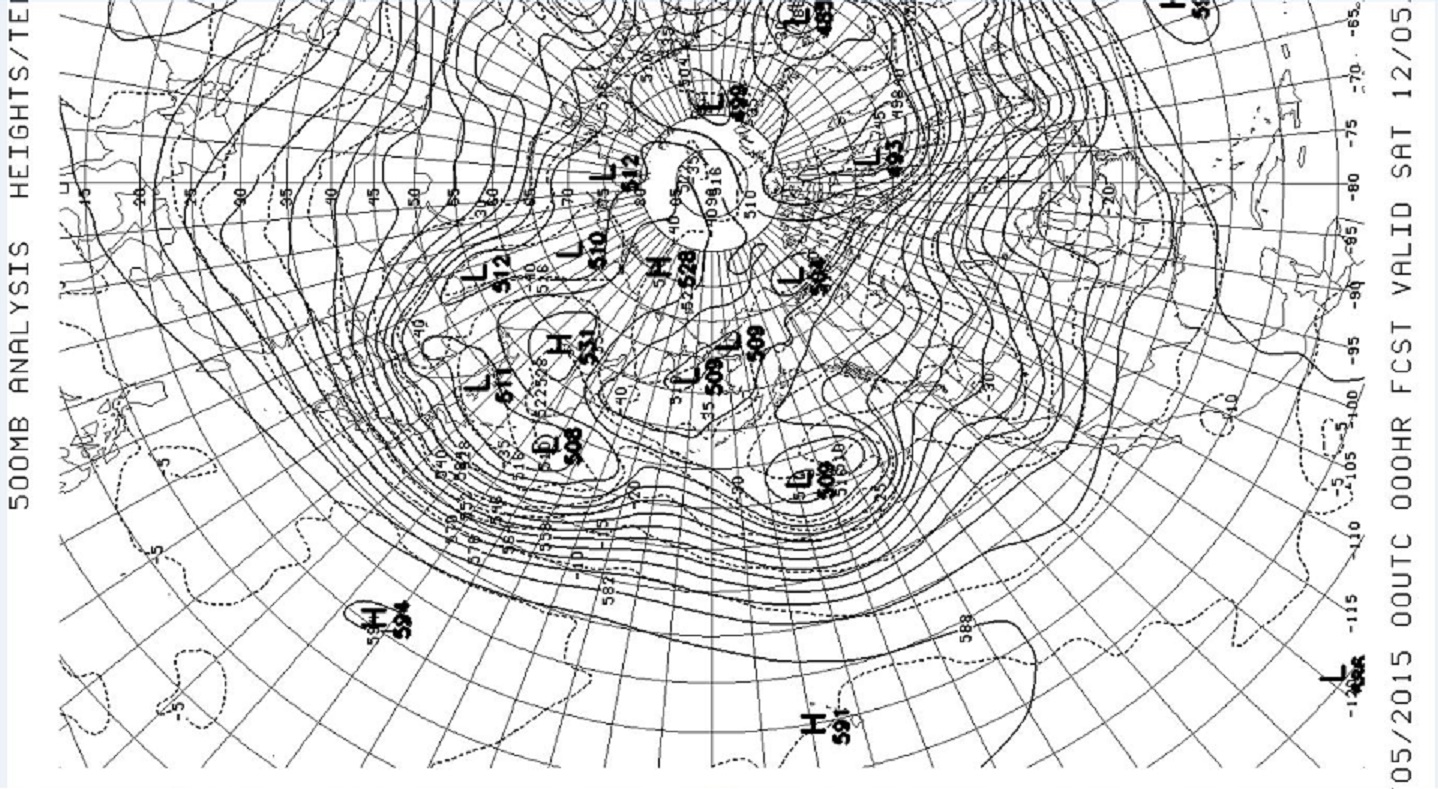
As forecast,  the jet stream across the Pacific has narrowed into a more concentrated flow directed right at the West Coast.

December 05, 2015ulldisknorhemi500mb0000z - Copy

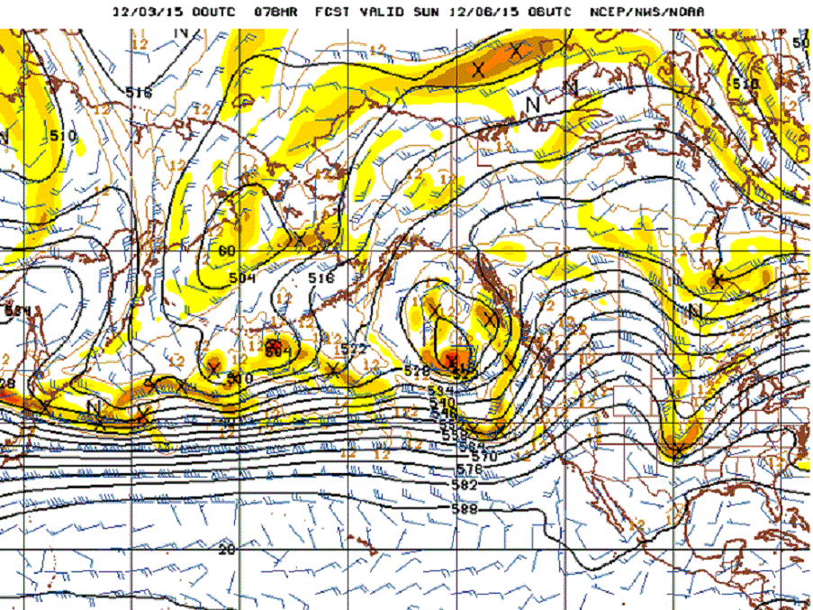
The forecast map from 2 days ago showing the same west to east jet steam as  the  current analysis above.December 03, 2015bloggfs_npac_078_500_vort_ht - Copy

So the El Niño Winter has begun. The current storm track is way too far north to have much impact on Southern California at the moment. But with the recent November SST (sea surface temperatures) record in the 3.4 Niño region. Impact on Los Angeles and San Diego can only be considered imminent.

Learn more in my latest e-book El Niño:  The WILD side of the weather cycle…
What we know, what we don’t, and WHY you should care!

I show how this years Pacific water temperatures compare to the 1982 and 1997 events and highlight the kind of weather episodes that these stronger El Niño’s tend to bring.

If you like the blog you will love the book.

Cover2

Available at Amazon

Wild Bill.
Finally a Series of storms for California.

December 03, 2015

Today, the first in a series of early December storms will roll across portions of Oregon and Northern California.  Inches of rain and feet of snow driven by winds to hurricane force will impact this wide region Thursday the 3rd into Friday the 4th of December.

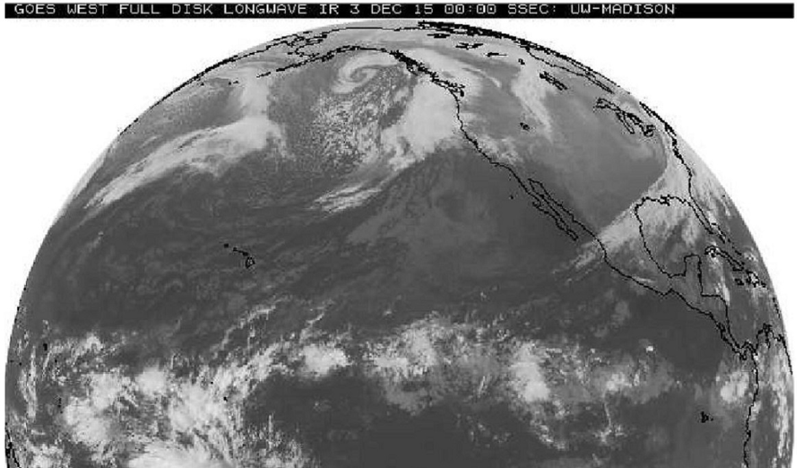
The image below is from late Wednesday, the storm is poised just off the coast.December 03, 2015westfulldiskIR0000z - Copy

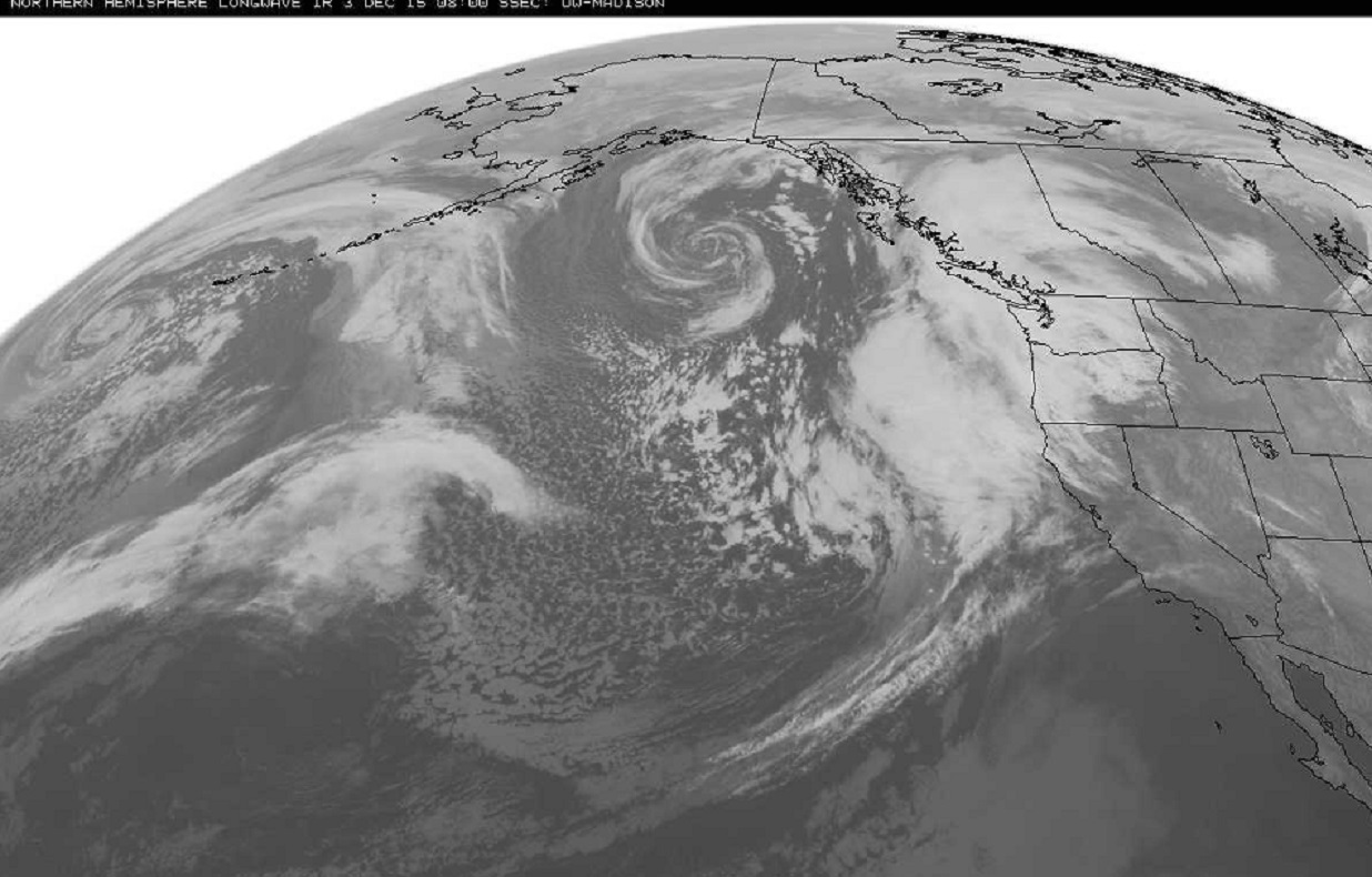
Closer view 8 hours later, early Thursday morning 0800z. Solid cloud cover associated with steadier precipitation. Speckled clouds west side of storm system a sign of cold air streaming south and a vigorous strengthening system.  Big storm … today.

December 03, 2015 Bloglatest_west_0800ir4_nh - Copy

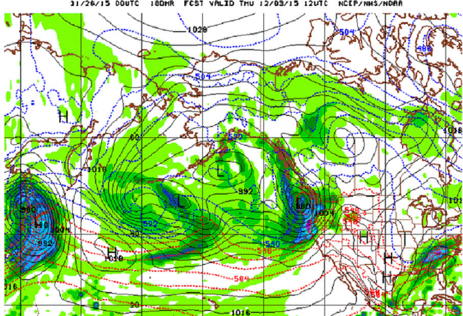
Forecast map for Thursday morning December 3rd from this  Blog post a week ago.November 26, 2015Bloggfs_npac_180_surf - Copy

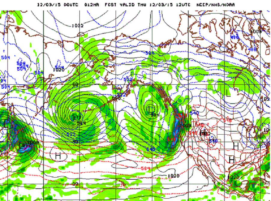
Forecast map for Thursday morning December 3rd from Wednesday evening.

Compare storm location and strength of system approaching West Coast, also notice Southeast storm in reality has already moved out.December 03, 2015gfs_npac_012_1000_500_thick - Copy

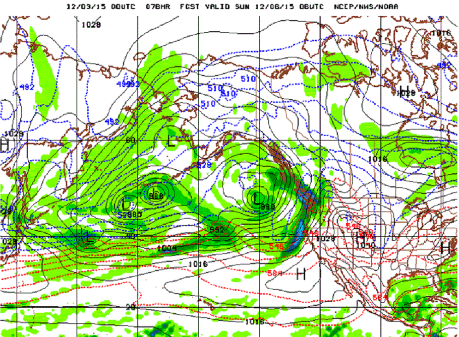
So, this particular run of the model did a little better with timing on the West Coast system. As we look ahead a few more days to this weekend. This “particular run of the model” begins to take on the “atmospheric river” configuration that the West Coast and especially California needs to be ready for as the more serious winter storms appear to be upon us.December 03, 2015bloggfs_npac_078_1000_500_thick - Copy

A series of storms spread across the Pacific Ocean all headed toward our West Coast and portions of California, but not necessarily Los Angeles or San Diego, at least not at first. This first series of storms appears to target the Southern Cascades, the Siskiyou, and the Northern Sierra Nevada.  Southern California may do better with a system toward the end of the series around Thursday the 10th. December 03, 2015bloggfs_npac_078_500_vort_ht - Copy

It really is quite the chart. A straight shot right across the Pacific. The search for a good example of the Pacific “atmospheric river” for Chapter II of the book took me back to January of 2010.  Now here we are early December 2015 with one of the strongest  El Niño ever and the forecast model just starts spitting out great examples of this relatively rare phenomena.

The average SST (sea surface temperature) anomaly for November 2015 was +2.98. A three month running average of 1.50 is considered significant.

A long and eventful Meteorological Winter has indeed begun.

Learn more in my latest e-book El Niño:  The WILD side of the weather cycle…
What we know, what we don’t, and WHY you should care!

I show how this years Pacific water temperatures compare to the 1982 and 1997 events and highlight the kind of weather episodes that these stronger El Niño’s tend to bring.

If you like the blog you will love the book.

Cover2

Available at Amazon

Wild Bill.
A +2.98 means November SST’s were record warm.

December 01, 2015

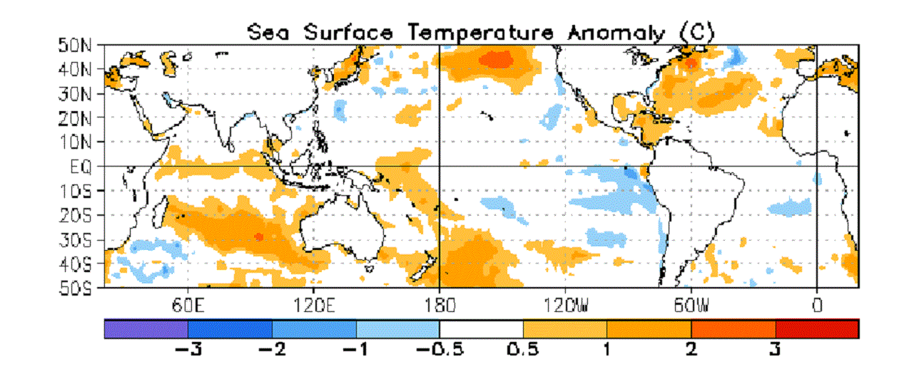
Despite a slight decrease in weekly SST’s  this week, a +3.0 for the final week of the month was warm enough to give November a record high average. The average SST (sea surface temperature) anomaly for November 2015 was +2.98. The warmest month previously was January of 1983 at +2.79. The warmest month in record season of 1997 was December at +2.69.  Values used for my calculations listed below were retrieved from the CPC’s website.

———————————————————————————————————————-

Latest weekly SST’s for the 3.4 Niño region

04NOV2015        29.5   +2.8                             05NOV1997     29.2   +2.6
11NOV2015        29.7   +3.0                             12NOV1997     29.3   +2.7
18NOV2015        29.7   +3.1                             19NOV1997     29.3   +2.7
25NOV2015      29.6   +3.0                            26NOV1997     29.4   +2.8

Nov. average   29.6   +2.975                                                 29.3     +2.700

———————————————————————————————————————-

Warmest monthly SST’s for the 3.4 Niño region
YR   MON   NINO3.4    ANOM
1982  12      29.21    +2.64
1983   1        29.36    +2.79

1997  11     29.32    +2.67        (29.3     +2.700)
1997  12     29.26    +2.69
2015  10    29.15    +2.46

2015 11    29.60   +2.98

The monthly averages will be officially update on the CPC website later this week, we will revisit the subject at that time.

———————————————————————————————————————

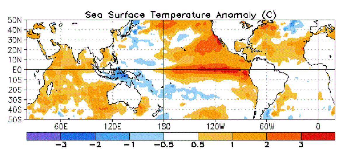
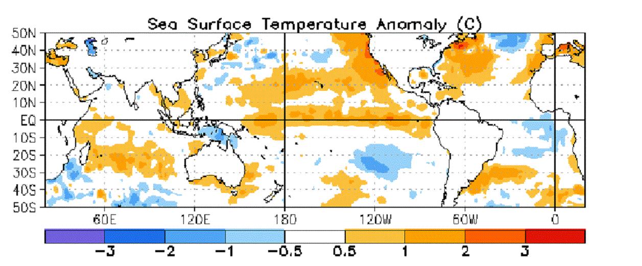
A graphical representation of the current Eastern Pacific warming compared to last year and the year before.December 01, 2015BlogOctober2015SST - Copy

November 2014, last year, just a hint of the coming event.December 01, 2015BlogNovember2014SST - Copy

November 2013, two years ago, nothing of note in the eastern Pacific.December 01, 2015BlogNovember2013SST - Copy

This El Niño event is a big deal. I am afraid the real “fun” has barely begun.
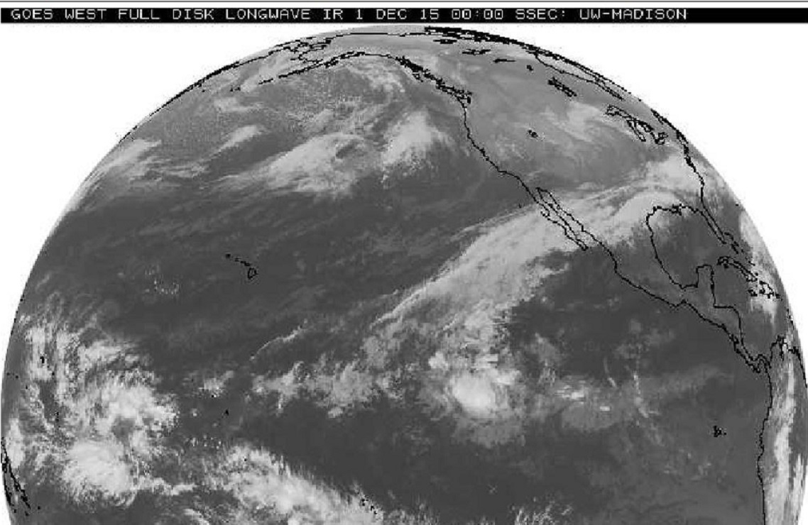
Monday evening satellite image clearly showing the moisture connection from the Eastern Equatorial Pacific into North America. Tropical systems Rick and Sandra are long gone but the tropical connection to the 3.4 Niño region persists in the early days of December.

December 01, 2015westfulldisk0000z - Copy

Here is a couple of quick lines from Chapter IV of my book that illustrate why this connection can be a winter long problem.

“The impact of the 1983 El Niño was pretty far reaching right here in the U.S. A winter so wet, over such an expansive area, that two of our biggest river basins were still above flood stage entering the summer months. Pacific Ocean temperatures as warm as 1983 at this point in the season is NOT a good thing.”

“the two biggest floods on the Lower (Mississippi) River Basin, … have been during Pacific warming events.”

Learn more in my latest e-book El Niño:  The WILD side of the weather cycle…
What we know, what we don’t, and WHY you should care!

I show how this years Pacific water temperatures compare to the 1982 and 1997 events and highlight the kind of weather episodes that these stronger El Niño’s tend to bring.

If you like the blog you will love the book.

Cover2

Available at Amazon

Wild Bill.